If you’re a fan of Wisconsin road trips, you’ll definitely want to join us as we talk about how you can travel Wisconsin’s Scenic Byways all year long! Scenic byways are non-interstate highways that are at least 30-miles long and offer travelers numerous scenic and/or historical attributes to enjoy and explore. One important factor in getting out and hitting the roads is to make sure you buckle up and keep your phone down. Before planning your trip on Wisconsin’s scenic byways take the Wisconsin Department of Transportations pledge to #BuckleUpPhoneDown and remember to practice safe driving in order to get to your final destinations!
The Great River Road
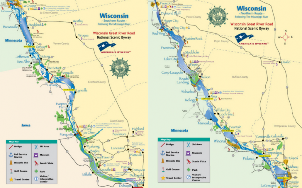
Photo Credit: Wisconsin Great River Road
Wisconsin’s Great River Road is 250 miles long and goes through 33 river towns. Each community has its own story to tell and is what makes this unique journey an unforgettable one! If you haven’t done this road trip…it truly is a Wisconsin must! Mostly along Highway 35 on the western side of the state is the Great River Road. Which great river? None other than the Mississippi River!
Did we mention that earlier this year, the Great River Road got the All-American Road designation?! While in Grant County, the road goes along Highway 133 through Potosi and Cassville and those small county roads provide extraordinary views the entire way through The Driftless Area. Be sure to stop along the way at one of the rest stops to get out and take some pictures of your memorable road trip! And remember, buckle up and keep that phone down while driving! See a map of the Great River Road here.
Lower Wisconsin River Road
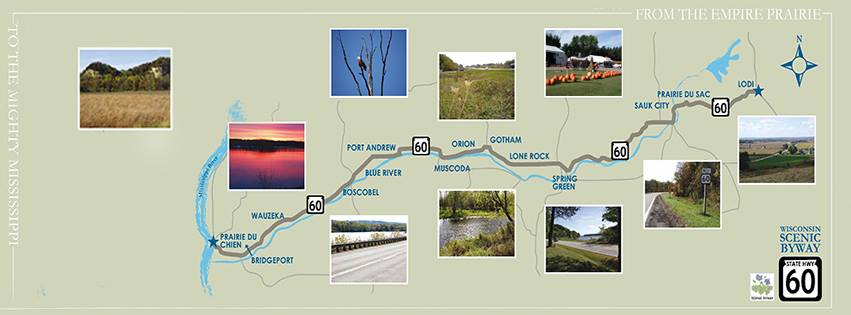
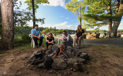
Photo Credit: Wisconsin Scenic Byway 60 via Facebook
Easily accessible from the Great River Road is the Lower Wisconsin River Road. This 100-mile scenic byway rides along the lower Wisconsin River in The Driftless Area. This road starts at Highway 60 in Wauzeka, but then you can ride right along Highway 131 to get all the views up until Tomah!
Along the Lower Wisconsin River Road, you can drive right through the Kickapoo Valley Reserve and pass over the Kickapoo Valley River 11 times! Then, travel along the Elroy-Sparta Trail and up to Tomah through the gorgeous Driftless Area. If you’re lucky enough to get there during the fall, you will be absolutely stunned! See a map of the Lower Wisconsin River Road here.
About a mile off the drive is Wildcat Mountain State Park and it is definitely worth the time spent traveling there. If you’re up for a hike while visiting, you can explore 21 miles of scenic hikes, nature, and equestrian trails throughout the park! This is the perfect place to pull off and pull out your phone to take the most gorgeous views. Remember to buckle up when you get back to the car and put your phone down until you get to your next stopping point.
Door County Coastal Byway
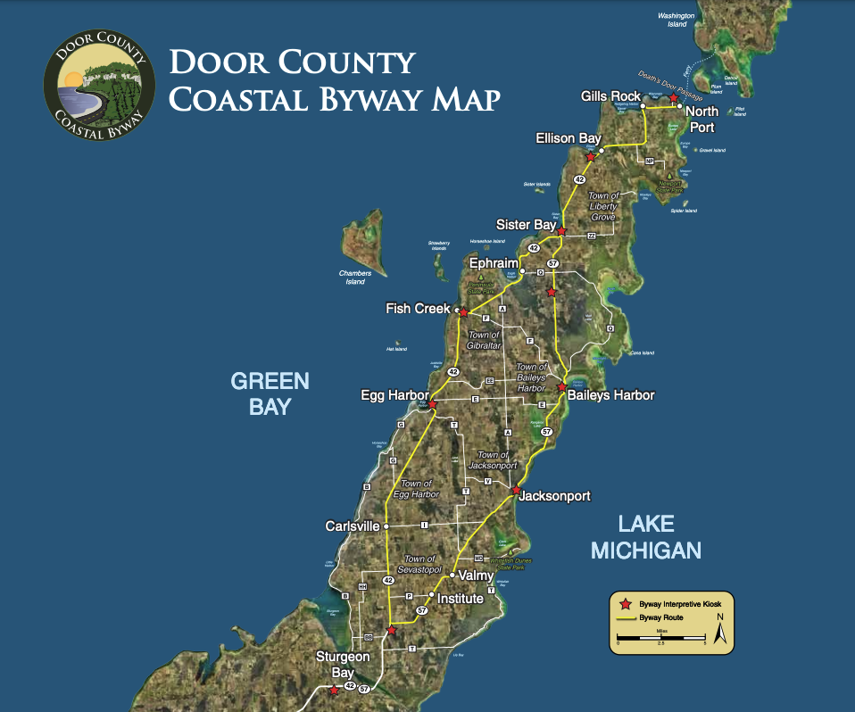
Photo Credit: Door County Coastal Byway
In the northeastern part of the state, you can drive along the iconic Door County Coastal Byway. This National and Wisconsin scenic byway covers over 66 miles through the beautiful Door Peninsula. Following along Highway 57 you can travel from Sturgeon Bay all the way to the top of the peninsula to Northport and Gills Rock and then back down along Highway 42 where you began the trip.
Whether you are looking to take a scenic ride along Lake Michigan, or the bay of Green Bay, and the Niagara Escarpment bluffs, this ride gives you the best of both worlds! Not to mention, you can get out and explore a state or county park, see some gorgeous lighthouses, and get an incredible bite to eat. You can do that all along the Door County Coastal Byway! Remember to take a break and get out of the car to take your beautiful pictures along the drive. See a map of the Door County Coastal Byway here.
Wisconsin Lake Superior Scenic Byway
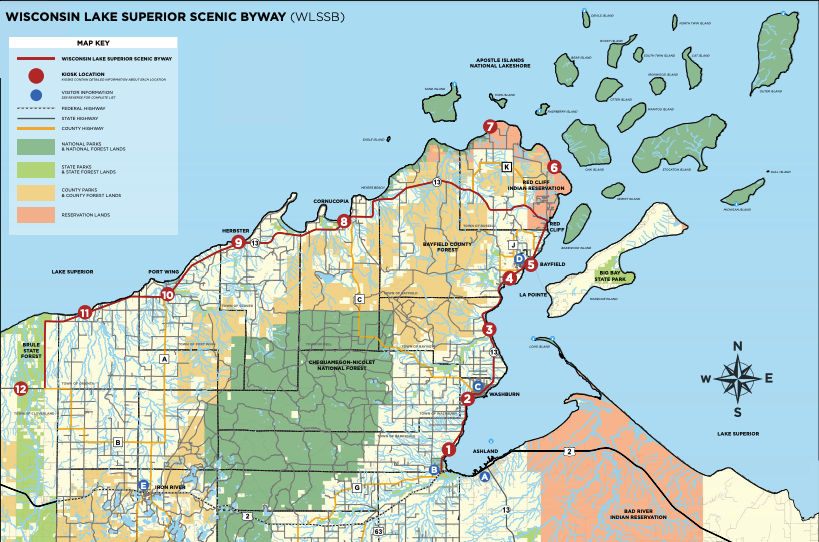
Photo Credit: Wisconsin Lake Superior Scenic Byway
The Wisconsin Lake Superior Scenic Byway is a 70-mile route through forests, beaches, and along the crystal clear waters of Lake Superior. Home to the Apostle Islands National Lakeshore and the Gaylord Nelson Wilderness Area, you are in for a treat while exploring these iconic and stunning areas of the badger state!
The byway travels through the small harbor towns and really allows those who travel the road, to experience the stories and scenery of Lake Superior. But, if you really want to get intertwined with the byway and get rewarded with everlasting memories, be sure to try local restaurants, enjoy a nice walk along Lake Superior, and if it’s warm enough…take a dip in the water! Don’t forget to buckle up, put your phone down, and pull over to take your outstanding pictures along the way! See a map of the Lake Superior Scenic Byway here.
Nicolet-Wolf River Scenic Byway
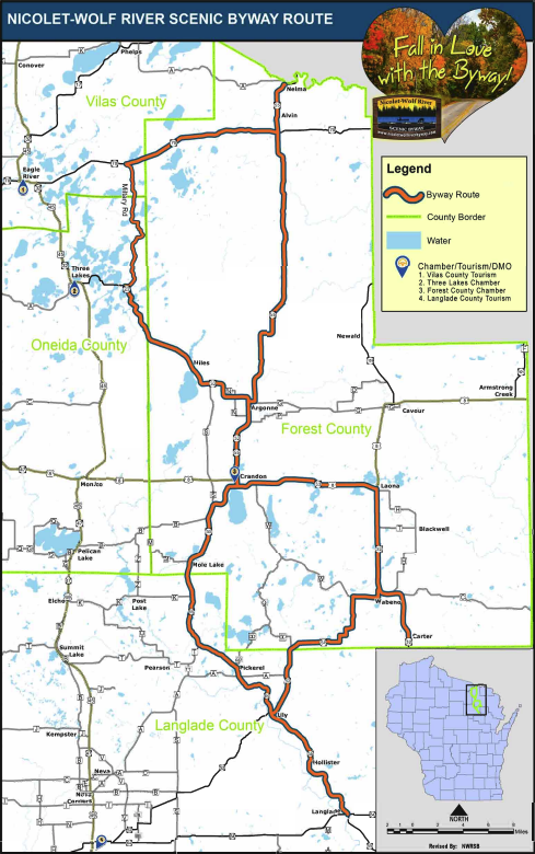
Photo Credit: Wisconsin Lake Superior Scenic Byway
Last but not least, we have to talk about the newest Wisconsin scenic byway: the Nicolet-Wolf River Scenic Byway that goes through the heart of the Chequamegon-Nicolet National Forest. This 145-mile route winds through the northern counties of Wisconsin with beautiful scenic roads, a blend of culture, and active wildlife!
In Forest, Langlade, Oneida, and Vilas County, you can really see what life is like in the Northwoods. From a slower pace of life and ‘taking the long-way home’ to family owned businesses with hometown hospitality, this scenic byway gives a great taste of the Northwoods lifestyle. Be sure to buckle up on your drive and put your phone down along the way so you can enjoy the beautiful views when you arrive at your destination! See a map of the Nicolet-Wolf River Scenic Byway.
—
From The Driftless Area, to the Apostle Islands, to the Door Peninsula, you can get out and travel along the many Wisconsin Scenic Byways all year long! Thanks to our friends at the Wisconsin Department of Transportation, we are here to remind those who are traveling to get to your destination safely by starting off with first buckling up your seat belt and second, keeping your phone down while driving. To stay committed to this promise and our fellow roadside travelers, we’re taking the pledge with the WisDOT to #BuckleUpPhoneDown. You can join us in taking the pledge to #BuckleUpPhoneDown here. Watch a Discover Wisconsin original short, ‘It’s A Sign’, now and see how we explore the Wisconsin scenery from Menomonee Falls to Green Bay:
Or buckle up and listen to ‘The Road Less Traveled: Wisconsin Road Trip Inspiration’ now on The Cabin Podcast. Get an inside take from the master of road trips (aka Eric Paulsen) through 5 scenic, must-see road trips to do throughout the state!
—
About Wisconsin Department of Transportation: The Wisconsin Department of Transportation (WisDOT) was officially established in 1967 by combining formerly independent agencies and the Department of Motor Vehicles (which included the State Highway Commission, State Aeronautics Commission and State Patrol). WisDOT supports all forms of transportation. The department is responsible for planning, building and maintaining Wisconsin’s network of state highways and Interstate highway system. The department shares the costs of building and operating county and local transportation systems – from highways to public transit and other modes. WisDOT plans, promotes and financially supports statewide air, rail and water transportation.
—
Kortnee Hass: Digital Media Associate for Discover Mediaworks. A Wisconsin ‘now & forever’ transplant with a soft spot for squeaky cheese curds, craft breweries, and all things Wisconsin tourism.